 |
EUROGEOGRAPHICSEurogeographics is an independent non-profit organization that brings together national institutions in charge of cartography, cadastre and land registration in Europe, which base their activities and membership in this organization on the common belief that modern society requires reliable geospatial data and services that are the sourced by these particular institutions. Established in 2001, this organization has more than 60 members from 46 countries today, which make up approximately 90 % of the official bodies in Europe responsible for geodetic measurements, topographic mapping, cadastral surveying and land registration. The Republic Geodetic Authority represents the Republic of Serbia and participates in the activities of the EuroGeographics organization since October 2004. Participating in joint activities and exchanging experiences with other members, the Republic Geodetic Authority equally provides a range of products and services and expertise needed for navigation, an adequate response to various emergency situations, information for a reliable and safe property market, as well as an information basis for many decisions and services of the public administration, business sector and citizens. |
   |
UN-GGIMEstablished in July 2011 by a resolution of the United Nations Economic and Social Council (ECOSOC), the Expert Commission for Global Geospatial Information Management (UN-GGIM) aims to establish a global agenda for the development of geospatial information, as well as to promote the importance geospatial information for dealing with major global development challenges. In accordance with this goal, the UN-GGIM is committed to providing a mechanism for joint decision-making and the creation of common guidelines for the production, availability and use of geospatial information within the national, regional and global framework for the creation and management of policies, which are important for the achievement of the 17 Sustainable Development Goals (SDGs). Relying on the national capacities of member countries to achieve the above global goal, the UN-GGIM initiated the establishment of regional expert commissions in addition to the Expert Commission at the global level. Thus, the UN-GIMM Expert Commission for Europe (UN-GIMM: Europe) was officially established in October 2014, with the aim that relevant experts from 56 countries, including the Republic Geodetic Authority of the Republic of Serbia, whose representative is currently a member of the Executive Board of this Expert Commission, support the achievement of the global goal in accordance with the specifics traits of the local level. In addition to participating in the work of the Executive Board, representatives of the Republic Geodetic Authority are also active in several UN-GIMM: Europe Working Groups (such as the Working Group for the Integrated Geospatial Information Framework (IGIF) and the Working Group for Sustainable Development Goals, organized around key topics or challenges for the efficient and effective management of geospatial data in Europe. Given its competences, as well as the need to emphasize and better understand the importance of geospatial information for the development of modern society in the Republic of Serbia, the Republic Geodetic Authority has joined currently small number of UN-GIMM member countries that will translate the entire documentation on access to and advantages of the development of geospatial information (IGIF) into their native Serbian language. |
 |
UNECEThe United Nations Economic Commission for Europe (UNECE) was established in 1947 by the United Nations Economic and Social Council (ECOSOC) with the aim of actively supporting and improving economic cooperation between European countries, as well as the cooperation of European countries with other member countries of the United Nations. Apart from the Republic of Serbia, which has been involved in the work of this Commission practically since its establishment, a total of 56 member countries of the United Nations from Europe, North America and Asia, as well as over 70 international professional organizations and other organizations from the non-governmental sector, participate today in the work of UNECE. In accordance with the globally recognized challenges of development in the 2030 Agenda for Sustainable Development, which was adopted in 2015 at the Summit on Sustainable Development in New York, UNECE through its working bodies intensively encourages activities aimed at achieving the 17 sustainable development goals. One of the UNECE working bodies, the Working Party on Land Administration (WPLA), in whose activities the Republic Geodetic Authority actively participates, aims to establish and develop a reliable land administration for sustainable land management, as a key element and starting point for economic and social development that will not damage the environment and existing resources. By closely cooperating and exchanging experiences with representatives of land administrations of other countries from the UNECE region, the Republic Geodetic Authority improves its capacities, which are of vital importance for responsible and transparent land management in the Republic of Serbia, as well as the realization of the principles of good governance and open government. |
 |
UNGEGNThe United Nations Group of Experts on Geographical Names (UNGEGN) was established in 1967 under the auspices of the United Nations Economic and Social Council (ECOSOC). As the highest organization in the field of toponymy, UNGEGN gathers experts in the fields of cartography, linguistics and related disciplines, and performs its work through the activities of 24 divisions and 10 working groups. The Republic of Serbia is part of the East Central and South-East Europe Division (ECSEE). Working groups are trained to deal with specific toponymic disciplines - data management, toponymic terminology, romanization, financing and education, exonyms, cultural heritage, evaluation, implementation and publication, country names, tasks in Africa and development of toponymic guidelines. The working body of the Government of the Republic of Serbia in charge of cooperation with UNGEGN is the Committee for Standardization of Geographical Names, chaired by a representative of the Republic Geodetic Authority. The Committee consists of experts from 11 state institutions of the Republic of Serbia. |
 |
CLGEThe role of the Council of Surveyors of Europe (Comité de Liaison des Géomètres Européens, CLGE), which was established in 1962 and has existed under its current name since the congress of the International Federation of Surveyors (FIG) held in Wiesbaden in 1972, is to represent and promote the interests of the surveying profession in the public and private sectors in Europe. Given the importance of this Council for the improvement of the status of surveyors and land administration in general and in the Republic of Serbia, the Republic Geodetic Authority has submitted a request for admission to the full membership of the Council, while it currently has observer status. |
 |
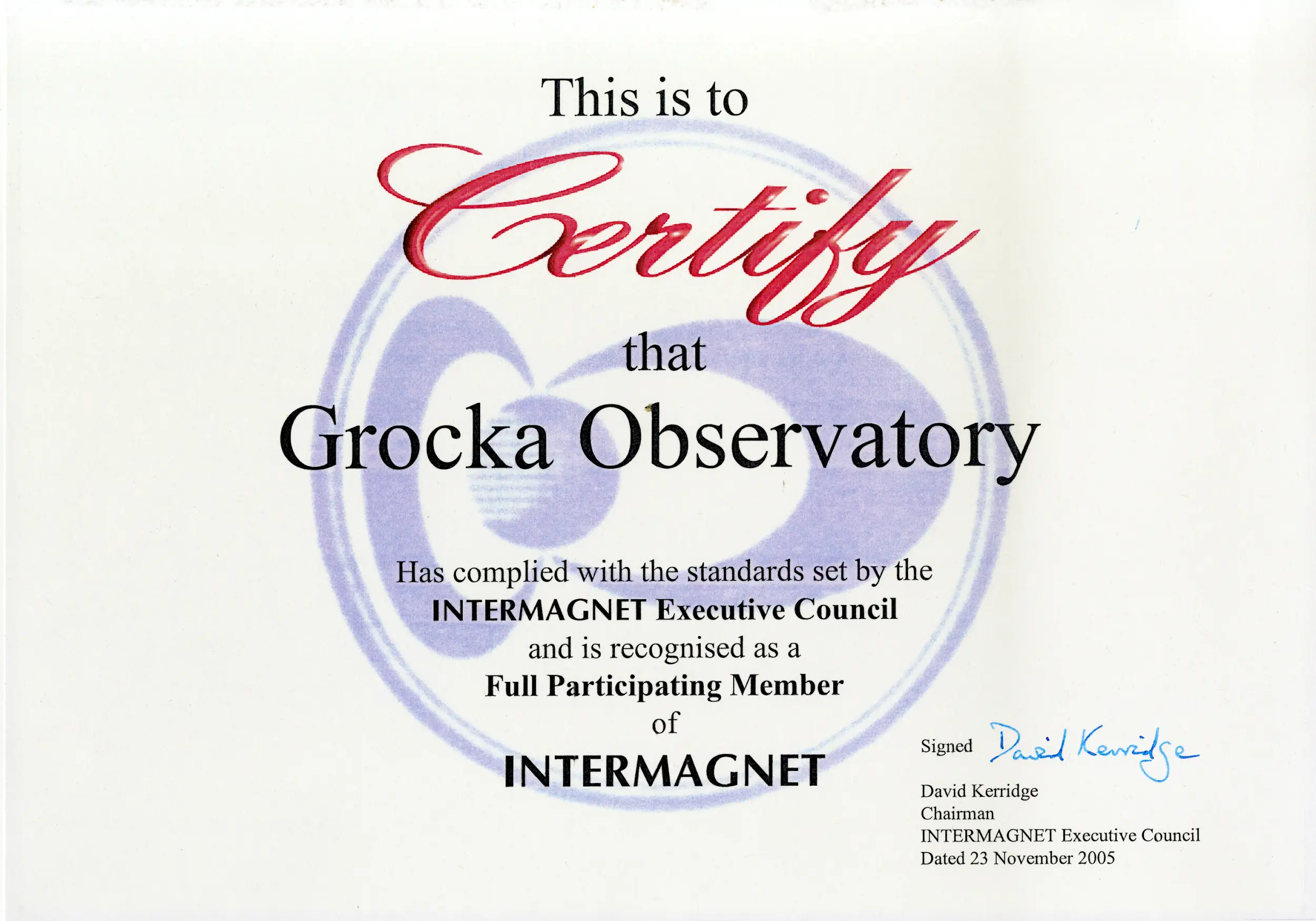
INTERMAGNETAfter successfully implemented technological automation and modernization in 2005, Geomagnetic Observatory Grocka (GCK*), established as part of the Center for Geomagnetism and Aeronomy "Milutin Milankovic" of the Republic Geodetic Authority, received a Certificate of fulfillment of the requirements for full membership in the global network of automated geomagnetic observatories for monitoring of the Earth's magnetic field - INTERMAGNET (International Real-time Magnetic Observatory Network). Today, this global network includes 154 observatories and 52 institutes around the world, which together support the mission of the INTERMAGNET program aimed at establishing an organization that will provide timely, consistent and high-quality geomagnetic data for all parts of the world, in accordance with the growing needs of scientific research aimed at wellbeing of modern society.
|
 |
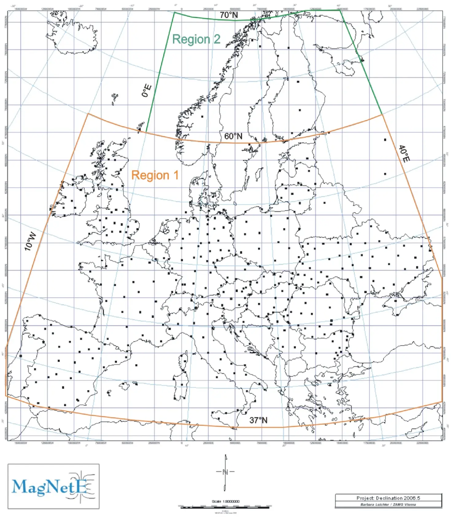
MagNetEBased on the results of geomagnetic surveys of the national territory, the Center for Geomagnetism and Aeronomy "Milutin Milankovic" of the Republic Geodetic Authority has been an active member of the European Association for Periodic Geomagnetic Measurements Magnetic Network in Europe - MagNetE (European Repeat Station) network since 2008. Workshops are organized at the five-year level at the European level, where geomagnetic maps for Europe are created based on the data of the relevant institutions. The results are published by the institution that organizes the workshop for the specified epoch.
European Repeat Station Network |
 |
IAGAThe Center for Geomagnetism and Aeronomy "Milutin Milankovic" of the Republic Geodetic Authority is a member of the International Association of Geomagnetism and Aeronomy (IAGA) for research in the field of geomagnetism and aeronomy. The goal of monitoring the Earth's magnetic field at the Geomagnetic Observatory Grocka (GCK), as well as at the network of secular stations and the network of first and second order points on the territory of the Republic of Serbia, is the participation and contribution of the Republic Geodetic Authority to the creation of a global model of changes in the geomagnetic field in the time and spatial domain. https://isgi.unistra.fr/iagaDivV/
|
 |
EPNEPN (EUREF Permanent GNSS Network) is part of IAG (International Association of Geodesy) responsible for:
The European Permanent Network (EPN) is a reference scientific-research base composed of about 400 permanently operational GNSS monitoring stations, whose precise coordinates calculated on a weekly basis are used by the EUREF sub commission of the International Geodetic Association (IAG) for the purposes of implementing and maintaining the European terrestrial reference system, ETRS89. The primary goal of the activities within the EPN is to ensure the homogeneity of coordinates on the territory of Europe. Homogeneity of coordinates is the main problem due to the rapid increase in the amount of the GIS data and the necessity of their interoperability and exchange between European countries. Institutionally supported by EuroGeographics and approved by the European Union as an integral part of the INSPIRE Directive, this reference system represents the backbone for all geographic, geodetic and geodynamic projects that are implemented on the territory of Europe, both at the national and international levels. The number of European agencies, institutes and universities participating in the implementation of EPN is constantly increasing, so the high reliability of the EPN network is based on redundancy and uniform rules, which guarantee the quality of both raw GNSS data and the resulting base station positions. In addition to its key role in defining the ETRS89 geodetic datum, data from the EPN network is also used for a wide range of scientific applications, such as monitoring deformations of the surface layers of the Earth's crust, monitoring and modeling the level of the world's seas and oceans, predictions, etc. The Republic Geodetic Authority through its control center of the national GNSS CORS (Continuously Operating Reference Stations) network within the EPN established the Local Analytical Center in April 2011 and it currently processes the data of 69 EPN CORS stations on a daily and weekly basis. At the same time, data are forwarded on an hourly and daily basis to other EPN local analytical centers from 7 stations of the national GNSS CORS network of the Republic of Serbia - AGROS. |
 |
CEGRN CONSORTIUMThe Central European GNSS Geodynamic Reference Network (CEGRN) was established in 1994 as part of a European project called CERGOP to ensure the long-term functionality of the Central European GNSS Geodynamic Reference Network. The CEGRN Consortium was founded in 2001 by the institutions that participated in the implementation of the project. The consortium is responsible for activities related to the operation, maintenance and development of the CEGRN network, coordinate measurements, data processing and cooperation in various research topics, and also represents the institutional basis for supporting various programs of the European Union. The Republic Geodetic Authority has been a member of the CEGRN Consortium since 2004 and actively participates in its activities. |